


Field Star
وصف لـField Star
Field Star is a seamless tool for obtaining coordinates of your locations, plotting UTM projected coordinates, Navigating to selected points and performing measurements of area and distance on the map.
Use Field Star for;
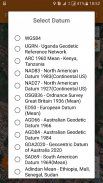
- Collecting UTM coordinates in both local and global datum applicable in
your country.
- Reconnaissance by Surveyors, Real Estates, Engineers, Geographers,
Physical planners. Giving both visual and quantified value of accuracy
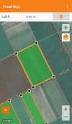
- Mapping your Land Parcels and Farming Lots
- Mapping different your points of interest
- Verifying the position of coordinates and parcels over the map
- Working with your own spatial layers saved as kmlLayers to verify and
ensure that your spatial data does not encroach on existing gazetted
features.
- Measuring area by selecting the plotted points and saving them as polygons
- Measuring Distances between Points and along routes.
- Retrieving stored points and polygons for further manipulation and use.
Main Components
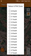
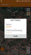
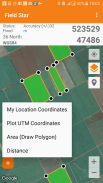
*** Settings: To change working datum for obtaining GPS Location
coordinates and Selecting a preferred UTM Zones for plotting coordinates
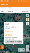
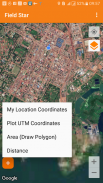
*** My Location Coordinates: Used for obtaining you current location. it
avails UTM Coordinates showing the coordinates(Eastings and
Northings), UTM Zone and Datum.
*** Plot Points: Field Star makes it possible to plot to the correct location on
the map, UTM coordinates from most local datum across the world. Every
continent is catered for.
*** Draw Polygons(Measure Area): Using this, you can select only the already
plotted points to join into a polygon or select both the plotted points and
other hand picked points to use to form a polygon. And obtain area
*** Measure Distance: Between plotted points or along a road or between any
points you hand pick on the map.
*** Saving Points and Polygons(area): All the above actions are made lasting
by the ability to store your measurements of points and areas.
All this data is persisted locally on your phone and Field Star
does not take way your data from you.
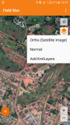
*** Map Layers: You can change between the satellite Layer type and Normal
Layer types of Included Google maps and Further ADD YOUR own Kml
Layer.
Field Star - إصدار 1.0
(09-01-2023)Field Star - معلومات APK
نُسخة APK: 1.0الحزمة: com.fieldstarآخر إصدار من Field Star


تطبيقات من الفئة نفسها


قد يعجبك أيضًا...


